The Hop Ev OHRV trail system is CLOSED FOR THE 2023 – May 2024!!
Updated:11/15/2023
See MVTR Facebook page for real-time information!

Download Full Size NEW Map by clicking on map above or HERE. **River Loop and Bob Thomas Trail (BT) are now run the opposite direction. The map added 6/21/22.**
HOPKINTON-EVERETT RIDING AREA aka “Clough” or “Hop-Ev”
Located in the towns of Dunbarton and Weare, the area is one of the oldest of the State’s public riding areas and one of the few in southern New Hampshire. A Federal flood control zone owned and managed by the Army Corp of Engineers, the NH Bureau of Trails leases the property on an annual basis. All of the trails and infrastructure were developed with volunteer labor from the Merrimack Trail Riders (MVTR) beginning in the early 1980s. Since that time, MVTR and the State’s Bureau of Trails have partnered to maintain the OHRV trails within the riding area. MVTR utilizes self generated funds and monies from the State’s Grant-in-Aid Program (GIA) to cover the cost of maintenance. The GIA monies are derived primarily from OHRV registrations. The area is closed as warranted by Army Corp. flood water retention requirements and mud season, (mud season is typically late winter to May 23rd).
There is a considerable amount of work required throughout the year in maintaining the trails for use by all OHRVs (ATVs, Trail Bikes and UTVs). Volunteers are always needed and can offer their help with work parties by contacting the Trail Master or Administrator. For more on work parties, please visit here.
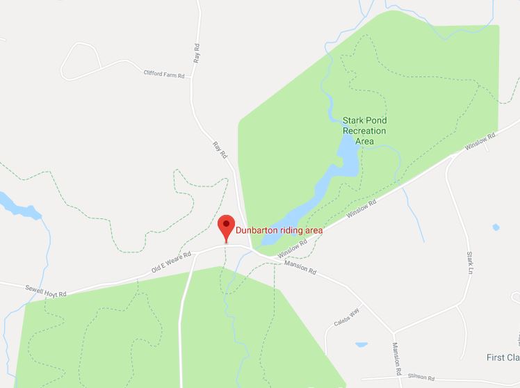
DIRECTIONS: The main parking area is at the junction of Ray, Winslow, and Old East Weare Roads in Dunbarton. From Rte 93 take 89 N to exit 2 / Rte 13 – Clinton St. Go South on Rte 13 to flashing light at intersection with Rte 77. Stay straight at flashing light onto Rte 77 and watch for Ray Road on the left across from the Transfer Station. Follow Ray Road through gate to the end and turn right into the parking lot.
VEHICLES PERMITTED: Trail bikes and ATV/UTVs with a maximum width of 50 inches and a maximum GVWR of 1000 lbs. (GVWR is the total weight of the empty vehicle and its maximum payload capacity). With some 100 bridges in the trail system designed for this size limitation, oversize vehicles may do damage to the system. Valid NH OHRV stickers are required.
VEHICLES NOT PERMITTED ON OHRV TRAILS: Jeeps, highway vehicles, or other oversize vehicles.
WINTER USE: Trails are open in the winter for OHRV use. Portions of the riding area are used by the local snowmobile club for their snowmobile trails. There are some sections of trail overlap where both are permitted simultaneously. OHRVs are not permitted on snowmobile only trails .
As a multi-use trail system, the trails are open to hikers, mountain bikers, horses, and dog sleds. Exercise caution and treat other trail users with respect.
Most trails are ONE WAY! There are some connecting trail sections open to two-way traffic, keep right and reduce your speed!
Stark Pond Loop: The easiest of the trails, it is open to both ATVs and Trail Bikes.
Bassett Mill Loop: A step up in skill level from Stark Pond the trail is open to ATV/UTVs and Trail Bikes.
Sugar Hill Loop: An intermediate skill level trail open to ATV/UTVs and Trail Bikes. It features hill ascents and descents, rougher terrain, and a shallow ford of the Choate Brook.
Hang Glider Hill Loop: An advanced skill level trail open to ATV/UTVs and Trail Bikes. It features steep hill ascents and descents, and rougher terrain.
Bob Thomas (BT) Trail and River Loop: Extreme skill level trails open only to Trail Bikes. Both feature rock gardens, very steep hill ascents and descents, ledges, and very rough terrain. The trail is typically 18” wide, there are narrow bridges, and narrow gaps between boulders and trees; the trails are one-way, and venture the farthest of the system from the parking area. It is recommended that first time riders on these trails have an experienced lead rider. These trails should not be ridden alone, less traveled; it may be some time before another rider comes upon you. The State has authorized these trails as “Trail Bike Only”.
PARKING LOT RULES
No dust, no donuts, and no wheelies. 10 MPH. No open fires.
TRAIL RULES
Trail Speed Limit: 25 MPH one-way sections, 10 MPH two-way sections and intersections.
Keep right on two-way sections.
No going backwards on one-way trails.
No “mud bogging” or going off the designated trail. State wet land violations are taken very seriously with high fines. This is Federal property; violations may be considered a Federal offence with subsequent fines.
No poaching of trails out of season or when the Riding Area is posted ‘Closed’: This is Federal property and violations may be considered a Federal offence.
The New Hampshire Bureau of Trails has authorized the Merrimack Valley Trail Riders as stewards of the Hopkinton Everett Riding area. Along with the responsibility of maintaining the trail system, MVTR has a responsibly to the Army Corp. of Engineers, to the State as the lessee that the property be respected; In order to protect the privilege of riding the Hopkinton Everett Riding Area, MVTR must be vigilant in assuring OHRV users respect State OHRV Rules and Laws. MVTR and OHRV riders are encouraged to make verbal contact with an offender, should the action continue or be deemed excessive, contact law enforcement